
Infrastructure BIM Services: Improving Design, Coordination and Construction Efficiency
Infrastructure projects are growing more complex. Roads, bridges, railroads, airports, tunnels and utility networks are big data, multi-disciplinary, tight schedule and high construction cost. If you attempt to manage all this information with traditional 2D drawings and disconnected workflows, you can end up with coordination issues, design changes, rework, and project delays.
Infrastructure BIM Services provide a digital approach to planning, design, coordination, construction and management of infrastructure assets. BIM allows engineers, designers, contractors and other stakeholders to work with greater visibility throughout the project lifecycle by creating intelligent 3D models linked with project information.
From 3D modeling of infrastructure and clash detection to 4D construction planning, quantity takeoffs and digital asset information, BIM is enabling infrastructure projects to be more coordinated and data-driven.
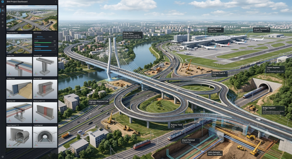
What Are Infrastructure BIM Services?
Infrastructure BIM services refer to the application of Building Information Modeling (BIM) methodologies to civil infrastructure projects.
Infrastructure BIM typically deals with large scale and geographically distributed assets, as opposed to BIM for individual buildings. Projects can involve complicated terrain, transportation networks, underground utilities, structures, and interconnected systems.
Typical BIM services for Infrastructure include:
Road and highway BIM modeling
• Bridge BIM modeling
• BIM modeling for railroads
• BIM Model of Airport
• Tunnel BIM construction
• Modeling of utilities and infrastructures
• Site and terrain design
• Modeling in Civil 3D
• Structural Modeling
• MEP and building services coordination
• Detect clashes
• Quantity take off
• 4D BIM construction planning
• Cost integration with 5D BIM
• 3D scan to BIM
• BIM as-built modeling
• BIM documentation and coordination
Why Is BIM Important for Infrastructure Projects?
Infrastructure projects typically involve numerous stakeholders and large volumes of technical information. A small design change can potentially affect multiple disciplines and project stages.
BIM provides a centralized digital representation that helps teams understand relationships between different project components.
For example, a road project may involve:
- Alignment
- Existing terrain
- Earthwork
- Drainage
- Utilities
- Bridges and structures
- Road furniture
- Signage
- Lighting
- Landscaping
- Traffic systems
When these elements are coordinated within a digital environment, project teams can identify potential conflicts earlier and make more informed decisions.
Major Applications of Infrastructure BIM Services
- Road and Highway BIM
BIM can support the planning and design of roads and highways by integrating alignment, terrain, drainage, utilities and other civil infrastructure components.
Road BIM workflows can include:
- Horizontal and vertical alignment
- Digital terrain models
- Corridors
- Intersections
- Drainage networks
- Road structures
- Utility coordination
- Earthwork calculations
- Quantity extraction
A coordinated road model can provide better visualization of the proposed infrastructure and its relationship with the surrounding environment.
- Bridge BIM Modeling
Bridge projects require coordination between structural components, roadway geometry, foundations and surrounding infrastructure.
Bridge BIM can represent:
- Foundations
- Piers
- Abutments
- Beams and girders
- Decks
- Bearings
- Reinforcement
- Expansion joints
- Barriers
- Approach roads
A detailed bridge model can help engineers and contractors review constructability and identify coordination issues before construction.
- Railway BIM
Railway projects involve long corridors and multiple interconnected systems.
Infrastructure BIM can be used to coordinate:
- Railway alignment
- Track systems
- Platforms
- Stations
- Bridges
- Tunnels
- Drainage
- Signaling infrastructure
- Electrical systems
- Utilities
BIM can help stakeholders visualize the railway corridor and coordinate individual assets within the wider project environment.
- Airport BIM
Airports are among the most complex infrastructure environments because they combine buildings, runways, roads, utilities, MEP systems and specialized operational infrastructure.
BIM can support:
- Terminal buildings
- Runways
- Taxiways
- Aprons
- Passenger facilities
- Baggage systems
- Utilities
- Airport roads
- Parking infrastructure
- MEP systems
A coordinated BIM environment can improve communication between architectural, structural, civil and MEP teams.
- Tunnel BIM
Tunnel projects involve complex underground conditions and require close coordination between civil, structural, geotechnical, MEP and safety systems.
Tunnel BIM can be used for:
- Tunnel geometry
- Structural elements
- Excavation planning
- Ventilation
- Drainage
- Fire protection
- Electrical systems
- Emergency systems
- Utility coordination
Combining BIM with survey and reality-capture data can also help teams better understand existing site conditions.
How Infrastructure BIM Improves Design
Traditional infrastructure design often requires multiple drawings and data sources to be reviewed independently.
BIM brings different information into a coordinated digital environment.
Better 3D Visualization
Three-dimensional infrastructure models allow project teams to understand complex geometry, terrain and spatial relationships more clearly.
Improved Design Coordination
Civil, structural, architectural and MEP disciplines can coordinate their designs within a common project environment.
Early Problem Identification
Potential design conflicts can be identified before construction, reducing the likelihood of expensive changes during execution.
Better Design Review
Stakeholders can review the proposed infrastructure digitally and identify design issues earlier in the project lifecycle.
BIM Coordination and Clash Detection
Coordination is one of the most important benefits of infrastructure BIM.
Large infrastructure projects can contain multiple overlapping systems. For example, underground utilities may intersect drainage networks, foundations or road structures.
BIM coordination can help identify:
- Utility clashes
- Structural conflicts
- Drainage conflicts
- Clearance issues
- Alignment problems
- MEP coordination issues
- Road and bridge interface problems
- Construction access conflicts
Major Advantages of Infrastructure BIM Services
1. Better Coordination
A common digital environment means multiple disciplines are able to work with better visibility.
2. Less Rework
By finding conflicts sooner, you can avoid the cost of changes made during construction.
3. Improved Project Visualization
3D models help to better understand and communicate complex infrastructure projects.
4. Enhanced construction planning
4D BIM enables linking project schedules to model elements for simulation of the construction sequence.
5. Improved Quantity Management
Quantity extraction, estimation and procurement can be supported by model based information.
6. Improved Project Communication
A common digital model can help enhance communication between owners, designers, contractors and consultants.
7. Improved Asset Information
BIM can be used to structure information that might be useful across the operational lifecycle of an infrastructure asset.
BIM for Infrastructure and Digital Twins
Infrastructure BIM can provide a crucial starting point for digital twin workflows.
A BIM model is basically a digital representation of information about an asset, while a digital twin can connect the digital representation with operational or real world data.
This can provide opportunities for infrastructure owners to: • Tracking of Assets
• Condition assessment
• Maintenance scheduling
•Operational analysis
• Measure performance
• Gestione del ciclo di vita
This shift is representative of a wider transition from project-oriented modeling to life-cycle-oriented digital asset management.
The Future of Infrastructure BIM
The future of infrastructure BIM is evolving to more integration between BIM, GIS, reality capture, cloud collaboration, automation, artificial intelligence, and digital twins.
Emerging workflows can assist project teams in managing ever-growing infrastructure datasets, while improving coordination and decision-making.
BIM automation can also help to reduce repetitive tasks such as model checking, data extraction, parameter management and documentation generation.
As infrastructure projects become more complex, BIM is evolving into a strategic information-management approach rather than just a 3D modeling technique.
Infrastructure BIM Modeler
An Infrastructure BIM Modeler plays an important role in developing accurate and information-rich digital models for roads, bridges, railways, airports, tunnels, and other civil infrastructure projects. Infrastructure BIM Modelers convert engineering drawings, survey data, design information, and point clouds into coordinated 3D BIM models. They work closely with architects, civil engineers, structural engineers, MEP teams, and contractors to improve design coordination, identify clashes, and support efficient construction planning.
Using advanced infrastructure BIM software, BIM Modelers can create detailed models for complex infrastructure components while maintaining accuracy, consistency, and project standards. A skilled Infrastructure BIM Modeler also supports model coordination, quantity extraction, documentation, design revisions, and construction-stage BIM requirements. This helps project teams reduce rework, improve collaboration, and make better decisions throughout the project lifecycle.
Conclusion
Infrastructure BIM Services are changing the way roads, bridges, railroads, airports, tunnels and other civil infrastructure projects are designed, coordinated and delivered.
BIM can offer project teams enhanced visibility and coordination throughout the project lifecycle by integrating 3D modeling, clash detection, quantity management, 4D construction planning, 5D cost workflows, Scan to BIM and asset information.
The use of a structured BIM workflow will help infrastructure owners, engineering consultants and contractors to develop better coordinated designs, improve construction planning and establish a better digital foundation for long term asset management.
Frequently Asked Questions
1. What are Infrastructure BIM Services?
Infrastructure BIM Services are professional BIM solutions used for roads, bridges, railways, airports, tunnels, utilities and other civil infrastructure projects.
2. What are the main benefits of Infrastructure BIM?
Key benefits include improved coordination, better visualization, early clash detection, construction planning, quantity management, improved documentation and better lifecycle information.
3. Is BIM used for road and highway projects?
Yes. BIM can support road alignment, terrain modeling, corridors, drainage, utilities, structures, earthwork and quantity management.
4.How does BIM help bridge projects?
Bridge BIM helps coordinate structural components, roadway geometry, foundations, reinforcement and surrounding infrastructure while improving visualization and constructability review.
5. What is 4D BIM in infrastructure?
4D BIM connects infrastructure model elements with construction schedules, allowing teams to visualize construction sequencing and planned project activities.
6. Can BIM be used for existing infrastructure?
Yes. Scan to BIM and reality-capture workflows can be used to create digital models of existing roads, bridges, tunnels, railway facilities, airports and other infrastructure assets.
7. What is the future of Infrastructure BIM?
Infrastructure BIM is moving toward integrated workflows involving cloud collaboration, GIS, automation, AI, reality capture, data analytics and digital twins for lifecycle asset management.
conclusion
Phone : +91 70301 51694
E-mail : contact@matrix-designs.com